StudentShare

Our website is a unique platform where students can share their papers in a matter of giving an example of the work to be done. If you find papers
matching your topic, you may use them only as an example of work. This is 100% legal. You may not submit downloaded papers as your own, that is cheating. Also you
should remember, that this work was alredy submitted once by a student who originally wrote it.
✕
Free
Field Survey Programme on Ape Distribution to Deforestation - Case Study Example
Summary
This work called "Field Survey Programme on Ape Distribution to Deforestation" describes the Congo River Basin’s rainforests, its geographical features, important wildlife areas for surveillance. From this work, it is clear about the list of primates found in Congo, future plans for this area. …
- Subject: Environmental Studies
- Type: Case Study
- Level: Undergraduate
- Pages: 4 (1000 words)
- Downloads: 0
- Author: carmen44
Extract of sample "Field Survey Programme on Ape Distribution to Deforestation"
Outline Plan for Field Survey Programme on Ape Distribution in relation to Deforestation in the Congo Rainforest The Congo River Basin’s rainforests are the second largest contiguous moist rainforests of the world after the Amazon rainforests of Latin America, and the Congo River is the second largest after Nile in the African continent. The unique combination of forest density, provision of a continuous water source and the hot, humid tropical climate provides a congenial habitat for a number of wildlife species which includes a number of sub-human primates. In fact, the Congo rainforests have attained a global reputation of harbouring the maximum variety of wildlife, although the same is not true for the population size of any particular species, which maybe more in some of the other wildlife areas in the world. One of the rarest forms of sub-human primate, the Pygmy Chimpanzee (Pan paniscus), commonly referred to as ‘bonobo’, and which is at a risk of extinction, is exclusively found only in the Congo rainforest and nowhere else in the world. The list of the most common genera, some of them with many species and sub species of primates found in Congo are as follows:
Allenopithecus nigroviridis (Allen’s Swamp Monkey)
Genus Cercocebus (Mangabey)
Genus Cercopithecus (Guenon)
Genus Colobus (Black & White Colobus)
Colobus guereza (Guereza)
Genus Euoticus (Needle clawed bushbaby)
Genus Galago (Lesser bushbaby)
Genus Gorilla (Gorilla)
Genus Lophocebus (Crested mangabey)
Genus Mandrillus (Drill)
Genus Miopithecus (Talapoin)
Pan troglodytes (Chimpanzee)
Papio anubis (Olive baboon)
Perodicticus potto (Potto)
Genus Piliocolobus
Pan paniscus (Pygmy chimpanzee, bonobo)
Geographical Features and Topography of Congo
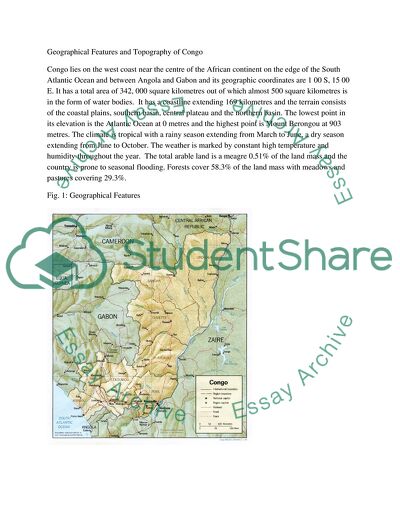
Congo lies on the west coast near the centre of the African continent on the edge of the South Atlantic Ocean and between Angola and Gabon and its geographic coordinates are 1 00 S, 15 00 E. It has a total area of 342, 000 square kilometres out of which almost 500 square kilometres is in the form of water bodies. It has a coastline extending 169 kilometres and the terrain consists of the coastal plains, southern basin, central plateau and the northern basin. The lowest point in its elevation is the Atlantic Ocean at 0 metres and the highest point is Mount Berongou at 903 metres. The climate is tropical with a rainy season extending from March to June, a dry season extending from June to October. The weather is marked by constant high temperature and humidity throughout the year. The total arable land is a meagre 0.51% of the land mass and the country is prone to seasonal flooding. Forests cover 58.3% of the land mass with meadows and pastures covering 29.3%.
Fig. 1: Geographical Features
Data for the ape distribution in Republic of Congo is available and well documented as shown in Fig. 2. Strategies can be developed to substantiate the available data through reconnaissance studies supported by satellite imagery. This can serve to yield some data for the estimation of the absolute abundance and habitat utilization of chimpanzees and gorillas in the intact forests
Fig. 2: Great Ape Distribution
In order to assess the rate of deforestation in relation to ape population, the pockets of the tropical rainforests harbouring the major species need to be identified, a census of the gorilla population made, the rate of deforestation calculated and the ideal space and food requirements per animal evaluated in relation to the available natural resources, food availability, reproduction patterns and gestation period of various sub species and the prevalence of life threatening diseases in the area. Most census activities are difficult to conduct as human assess to the deep rainforests is difficult as well as dangerous. Moreover the animals are in a constant state of movement which makes it difficult to establish a head count. However, modern approaches such as satellite imagery and computer assisted geographical information systems can be made use of to achieve some substantial data which can be evaluated with the proper statistical tools. Already population estimation studies are underway and census data from reliable sources can be obtained before endeavouring to conduct any qualitative or quantitative study. It has been confirmed that the Congo rainforests have the largest population of gorillas in the world and the latest estimated figure is around 125,953 gorillas living within an area of 47,444 square kilometres. However, despite this figure, it has been estimated that this population has declined significantly over the last three decades due to a combination of deforestation, Ebola haemorrhagic fever disease, illegal poaching and ingress of human populations into the natural habitat of Gorilla gorilla. The survey was conducted in areas shown in Fig. 3.
Fig. 3: Important wildlife areas for surveillance
The Congo rainforest is subject to large areas of deforestation with the forest cover decreasing by as much as 34.5% (1990). At this rate two thirds of the total forest area is likely to disappear by 2040. Remote sensing is an ideal way of measuring and evaluating the extent of deforestation likely to occur in the future (Fig. 4).
Fig.4: Deforestation in Congo
The survey programme needed for studying the impact of deforestation on the ape population has to begin at the ground level by positioning surveillance teams headed by qualified researchers from UK as well as Africa. Field staff can be hired after conducting proper screening, interview and determination of the ability of the native population to assist in the penetration of deep rainforests by road with multi terrain vehicles, movement on foot and by making use of appropriate photography and surveillance instruments needed for the study to identify and enumerate the primate population, the availability of natural food sources required to sustain that population. Ideally this activity requires a concerted day and night operation spread over a few months so that the total area can be screened from edge to edge. Availability of food, camping facilities, health equipment and medical assistance will be of primary concern. Aerial reconnaissance of the identified rain forests needs to be made by the use of helicopters before the ground job can begin.
The major identified areas in Congo include the Ndoki Likouala Landscape which spreads over an area of 27970 square kilometres, and includes two protected areas viz. the Nouabale-Ndoki National Park and the Lac Tele Community Reserve. The Batanga swamps encompass an area of 1029 square kilometres and include the Raphia swamp forest between the Ndoki-Likouala Landscape and the Batanga River. The third major area is the Ngombe-Ntokou-Pikounda Landscape which has a total area of 18455 square kilometres. This makes up a total area of 47454 square kilometres. For surveillance activity to be carried out effectively at least 20 surveillance teams with the responsibility of scanning approximately 250 square kilometres per team need to be prepared. Each team should have at least two researchers, an engineer, health professional and access to modes of conveyance such as all terrain vehicles (SUVs), motorboats, night vision equipment and an armed escort for protection against animals as well as criminals.
At a rate of 5 square kilometres of area surveyed per day, each team is likely to finish the ground surveillance in approximately one and a half to two months. Salaries cost of fuel, aerial reconnaissance, food and health coverage will have to be calculated depending upon the quality and quantity of personnel hired. The data collected by these teams can then be analyzed for making any inferences.
Read
More
sponsored ads
Save Your Time for More Important Things
Let us write or edit the case study on your topic
"Field Survey Programme on Ape Distribution to Deforestation"
with a personal 20% discount.
GRAB THE BEST PAPER
